26
Larapinta – Part 2 Ellery Creek to Simpsons Gap – 9 days
8/7 – 15/7/15
Western Macdonnell Ranges – Northern Territory – Central Australia
Hiking
Larapinta logistics
The logistics for the Larapinta are complex however you do it. Fantastic written resources are available
National Park package www.nt.gov.au/parks
Trek Larapinta website www.treklarapinta.com.au
John Chapman guidebook http://www.john.chapman.name/pub-lara.html
The simplest way is to walk the whole 220 km in one push. This requires from 12 to 18 days hiking for most people. On the sections we completed we saw lots of people doing this – some more experienced and better prepared than others. It’s a hard walk – long days, tough terrain, water carrying, hard on boots, feet, legs and shoulders. And sensational scenery in one of the most spectacular parts of arid Australia. In parts it’s more of a mountain walk than desert flatlands. You can either walk east to west (Alice Springs to Mount Sonder) or west to east. At Alice the walk starts or finishes in town so you only need to arrange transport to or from Mount Sonder (Redbank Gorge) – there are several transfer options. There are 3 regular food drop locations – you may be able to arrange transport of your food drops without you going out yourself.
A commercial trip is a good option for people wanting to do it as a series of day walks with transport, food and comfortable basecamping support. This will necessitate some long days and a fair bit of time in vehicles. You can do the whole trek or just the “highlights” (selected by the company). Reputedly fires each night and nice food.
Our trip
The Larapinta had beckoned for many years but sorting the best logistics was a challenge. In the end we did 121km in a 9 day continuous section that took in the commonly agreed best parts from Ellery Creek to Simpson’s Gap with an additional daywalk up Mount Sonder. In planning this route and itinerary some of the considerations were;
- We wanted to camp along the way and be self-supported so we could be fully immersed in the landscape
- Some of the best days are very long and have water logistics issues so we broke these long days into a series of shorter days where we would be able to carry enough water for overnight camps
- We scheduled the hardest days to be when our packs would be lighter due to having consumed most of the food prior to the food drops
- We would hire a 4WD to take in and bury an extra food drop in the middle of the hardest section – this was necessary as we could carry a maximum of 4 days food in addition to the water requirements day by day. We carried water for overnight camps on two occasions – Hugh Gorge to Birthday Waterhole (camping at Fringe Lily Creek) and Birthday Waterhole to Standley Chasm (camping on top of Brinkley Bluff)
- We would go as lightweight as possible to ease the load on knees, hips and feet (ages of walkers 58, 58, 60, 54, 52, 25)
- The overall cost for Cath and I was about $1250 each which included flights between Canberra and Alice Springs, accom in Alice, transfers, camp fees and our share of the 4WD
- 4WD cost $640 overall for the two days – we drove it from Alice Springs to Birthday Waterhole (to bury food drop) and then to Redbank Gorge for the Mount Sonder daywalk. Then the car was driven to Ellery Creek where the main party was dropped off. I continued on back to Alice where the car was returned. Next morning I got a transfer back to Ellery Creek where we started the main walk together.
Day 1 Ellery Creek to Rocky Creek 15 km (9.30 am – 4.00 pm)
Eastwards under the Heavitree Range we tramped weighed down by heavy packs – 4 days food and water for the day. We climbed up through a saddle that broke the range.  The scene that spread out before us as we descended on the other side was reminiscent of the great African rift valley. Same landscape and ancient atmosphere. Dry acacia scrub and grasses covered a huge open plain that stretched to a distant range of blue hills. We crossed dry, sandy creek beds and walked up and over small hills then along low ridge lines. Out in the flat lands it was hot and dry.
We settled in to a slow rhythm. Walking in chatting pairs or off in our own worlds. I’d known Sue for a long time and had some snippet insights into her past, the sort you piece together from fragments over years of working and doing things together. But as we walked together it was like the journey into this land paralleled my journey deeper into her story. She had studied anthropology, indigenous studies and sociology at ANU then worked in the public service for a year. With itchy feet she then travelled and worked in Europe and Asia for 2 years. Following this she worked as a curator in the indigenous section of the Australian Museum then for a time with the Canberra land management agency TAMS. From there she became a ranger at Kakadu for 3 years and Uluru for 2 years. A teaching qualification through Uni of Northern Territory enabled her to then work for 3 years as a teacher of little kids at Ramingining in a remote part of Arnhem Land. At this point her Mum got sick so she moved to Canberra and worked in the indigenous education unit and preschool. The next stage was 13 years at the Birrigai Outdoor School where I got to work alongside her for about 5 years. Everyone knew her as a wondrous, lively, treasure of a person. Then she was off to the UK for two years at another outdoor centre before returning to Canberra to work with refugee and migrant children at an Introductory English Centre. I had thought my own life and career had been interesting but marvelled at Sue’s career and life jam packed with wonderful adventures and meaning. How fabulous can one life be?

We reached camp tired but ok. This was one of the two less exciting days that were necessary for us to gain access to the best parts of the Trail. The night was filled with stars and milder than the frigid cold we expected. No fires so bed was a good prospect by 8.00 pm and sleep by 8.05.
Day 2 Rocky Creek to Hugh Gorge 16 km (8.30 am – 3.30 pm)
This was a long day across the undulating open plain. Rocky ridges provided great views of the gap in the range we were heading for. Slowly it got closer. Horse (?) droppings. Nice campsite next to a creek bed. Wash in a rock pool. Late in the day I scrambled high up on the side of the gorge for enticing glimpses into the rugged country we would walk through the following day. Our creaky knees and feet were sore but still under control. We were at a point where recue would be very limited for the next few days. Cath’s exercises were working a treat.
Over dinner we talked about refugees and asylum seekers. Sue regaled us with tales of the young students she worked with. These were heart-warming, gut wrenching and delightful. I could have listened to her all night.
Day 3 Hugh Gorge to Fringe Lilly Creek 10 km (8.30 am – 3.30 pm) *****
This was part of one of the long days we had broken into two. We carried double water as we were unsure of water supplies for the next night’s camp.
The gorge lived up to every part of its 5 star reputation. Pools reflected glowing orange walls that framed brilliant blue skies with dazzling white clouds. The white bark of gum trees seemed to shine with inner light. Over boulders. A side trip up a gorge, whose entrance was guarded on one side by a massive pinnacle buttress and on the other by a huge bluff, without packs, took us to the towering V shaped cliffs and an impassable pool. We collected some water here. More boulders.
 At Fringe Lilly Creek we camped on the sandy creek bed. Lots of flat stones were arranged and balanced in a cooking circle. A kilometre downstream we located the water hole that we had been told about. This meant we could have plenty for dinner, breakfast and the next day rather than scraping by with just enough.
Day 4 Fringe Lilly Creek to Birthday Waterhole 7.5 km (8.30 am – 3.00 pm) *****
 Uphill. Steep, zig zag track then a razorback ridge. Huge drop-offs each side. William and I scrambled some of the more spectacular narrow rocky ribs. Lookouts every 100 meters or so. Stupendous vistas all around stretching to far horizons. We were there. We were doing it.
This was better than the dreams and visions we had been picturing over years of anticipation. Like mountain walking in the French alps but with desert lowlands and no snow. Skirt the rocky outcrops. It was hard to believe we were climbing up this trail.

Cath was overwhelmed for the second time. Tears in her eyes, her heart exploded with gratitude that she could do it, that she could be in this country.
There was a top up there somewhere. But it was no better than the rest. Spinifex slopes led up to cliffed peaks. Stunted white gums clung to rocky slopes. My favourite arid country. A narrow foot track wound down and across steep slopes back to the other side of the range. Down Spencer Gorge and eventually to Birthday Waterhole.
 We excavated our food drop – sealed tins buried in the sand bed of the creek. Camp on the sand near the main waterhole. Later a couple of cars drove in and stopped nearby.
  One got bogged in the sand. I did them a favour, possibly saving a life, by using all my interpersonal skills to convince them to recover the car safely rather than the quick way they were planning. 4WD recovery training paid off. They were so pleased about getting sorted out that they happily took out our several kilograms of rubbish including the squashed tins. We would enjoy the benefits of this the next day.
Birthday Waterhole to Brinkley Bluff 8 km, (9.00 am – 2.00 pm) *****
 Cattle skulls and sun bleached bones had been collected and placed on trees on part of the track I called Death Valley. I lost concentration on this easiest part of the track which was flat and smooth underfoot leading up towards Stuarts Pass. My foot caught on a low termite mound and I tripped and landed face first on the hard ground. The pack, heavy with 2 days water and a new supply of food, pole drove my head into the dirt. It could have been curtains or at least a rescue but I was fine, just bleeding a little and with a growing egg on the forehead. Shaken up and reminded of the need to watch every step in this isolated place.
Stuarts Pass was named after the explorer John McDouall Stuart who had completed multiple epic feats of desert survival in attempts to cross through the centre of the continent from Adelaide to Darwin. He spent months at a time trudging in the heat with nowhere near enough food and water, half blinded by sandy blight. We morning tea-ed at his gap in the range. At home in the bush he was the hero of the colony when successful but his life ended poor and alone in the city.
 The climb up Brinkley Bluff was the biggest of the hike (500m ascent). With two days water! Slowly we inched our way up to a saddle then down to Rocky Cleft. It looked like the weather was going to hold so we kept on towards the top. Reputation had it that the top had few campsites and was very exposed. To camp on top was key to a lot of our planning. More zig zags tracked back and forth across the steep face of the mountain threading a route between rocky shelves. Up. Fabulous steep walking. More up. And then without the usual false summits we were on top. Whooping and hugging. A narrow track led through low scrub to the large cairn which was adorned with Himalayan prayer flags. They seemed strangely appropriate on this desert mountain top. The peak stood out proudly on its own affording amazing views in every direction. Amazing as well were the myriad of campsites that had been scraped out on top. Flat areas bordered with stones. Alone on the top, like the mountain, we found superb tent sites sheltered completely from the icy southerly wind in little sun traps just north of the summit ridge. It all had the feel of a high altitude mountaineering camp.


The afternoon was a heavenly treat. Perched above a million square miles of desert. Cups of tea on the mountain top. Exploring, photographing, doing exercises, relaxing. We felt on top of the world.  As the sun slowly set the light changed a thousand hills and directions to look and be transfixed.
In awe.
Colours changed on rocks, ranges, small eucalypts, spinifex and our multi-coloured tents. Rocky ridges plunged to the plains way below.

Stars appeared slowly at first then eventually lit up the whole sky. You could almost dip your hand into the Milky Way. I pondered the Aboriginal dreaming story of their elders who had died. The stars of the Milky Way were the campfires of their spirits which they sat beside as they kept watch over the people living below. It was a powerful image and spiritually comforting. Unknown to me at the time I was to come back to this story twice in the months that followed.
Day 6 Brinkley Bluff to Standley Chasm 10 km (8.30 am – 3.00pm) *****

The tent fly had been left off so we could lie in bed and see the stars. The morning star was still up when we awoke before dawn to an orange glow in the east below a deep blue canopy of sky. The night had been cold. Frost.
An extremely cold wind still blew on the southern side. Fully jacketed and thermaled we descended. The track twisted over narrow ridges, crossed through saddles and then traversed steep scree slopes. This reminded us of walking in the Dolomites. We had departed early and walked towards the light – peaks were shadowed, tussocks of spinifex shadow textured stoney hills. Rocky spines and ribs rose and fell away into crags dropping into the depths below.
 Downhill with packs mercifully lighter. Only half a day’s water and virtually no food. In the long gully below Reveal Saddle we passed through gardens of coloured flowers – pink, yellow, purple, white, red. Scramble over boulders.
Standley Chasm was an extremely welcome home away from home. Hot showers! We did the “hikers pamper package” – scones with jam and cream and coffee, sumptuous three course dinner and cooked breakfast – bliss! Clothes wash. Two of our group departed from here having completed their 6 day “best of the Larapinta” walk. Our daughter joined us for the next 3 days, starting off with the pamper package. She brought out some fresh tomatoes and lettuce and fruit to supplement our last food drop which was collected from the café.
Day 7 Standley Chasm to Jay Creek 13.6km (9.00am – 4.00pm)
 Up steeply with food filled packs. Tortured rocky peaks and pinnacles split by narrow gorges. Up and steeply down then up and down again. Stunning scenery yet again.
Scramble down a small crag that would have been a waterfall in the creek in the wet. Stony underfoot for kilometres. Hard work in the creek bed.
William and Elouise hiked up and down over the alternative high route as we made our way slowly along the flat. The last section was through deep sand.
Wearied we reached the shelter shed and water tank at Jay Creek.
Day 8 Jay Creek to Mulga Camp 11km (9.00am – 2.30pm)
 An easier day. Flatter terrain. We wound along the plain beside the range then passed through a gap and lunched “by a billabong under the shade of a coolabah tree”. We made camp early. Rest. This was another long day that we had decided to break into two. Relax. Snooze. Drink tea and soup. William was awarded the masterchef award. He broke out his Everest cake then showed us an extraordinary hook seeded bush he’d found.
  In the late afternoon together we scramble traversed the narrow ridge line between two gaps nearby.
At least once every day William exclaimed that this was the best walk he had ever been on.
Day 9 Mulga Camp to Simpsons Gap 14km (8.00am – 2.30pm)
A long day for us. Gently undulating. The vegetation was always interesting and varied. Packs were light, only lunch and snacks for one day. Arenge Bluff reared up majestic beside the path. Up and down over small rises, along creek beds and through flat mulga country. Chatting then quiet. One foot then the other. Count some steps. Adjust the shoulder straps. Check the map. Look at the everchanging view. Life was simple. We moved in comfort with each other. Treading gently through the country. Nearing our finish we started counting down the trail signs with their distance markers. One at a time. 4km. 3km. I must have missed one. At 1km our spirits soared. We did the last 50m again for the video camera.
What a route. What amazing scenery. Every detail had gone smoothly. Our bodies were sore now but that was ok. We had done it. The privilege of being there and being able to complete our journey was wonderful. For us it had been one of the hardest and longest walks we had done. And by far it had been the very best. A mountainous, gorge-ous walk through the desert ranges and plains of central Aus.
Notes on the walk
- All water (from tanks and pools) was purified using micropur tablets or a ceramic filter – we had no upset tummies (some others did).
- I would recommend walking west to east for aesthetic reasons. In walking towards the sun the ridges and hills are shadowed which gives the landscape much contrast and texture. If walking the other way the shadows would not be seen ahead so the landscape would constantly appear with a flat light without contrast and texture.
- We found water in Hugh Gorge and at Fringe Lilly Creek – this may not be reliable. We did not find water between Birthday Waterhole and Standley Chasm although we had heard there may be some at Stuarts Pass further down the creek line (we didn’t look).
- On the hard days the distance doesn’t indicate the difficulties and time necessary. With a light daypack and smaller amounts of water to be carried longer distances could be achieved but there would be less time to immerse and savour the landscape.

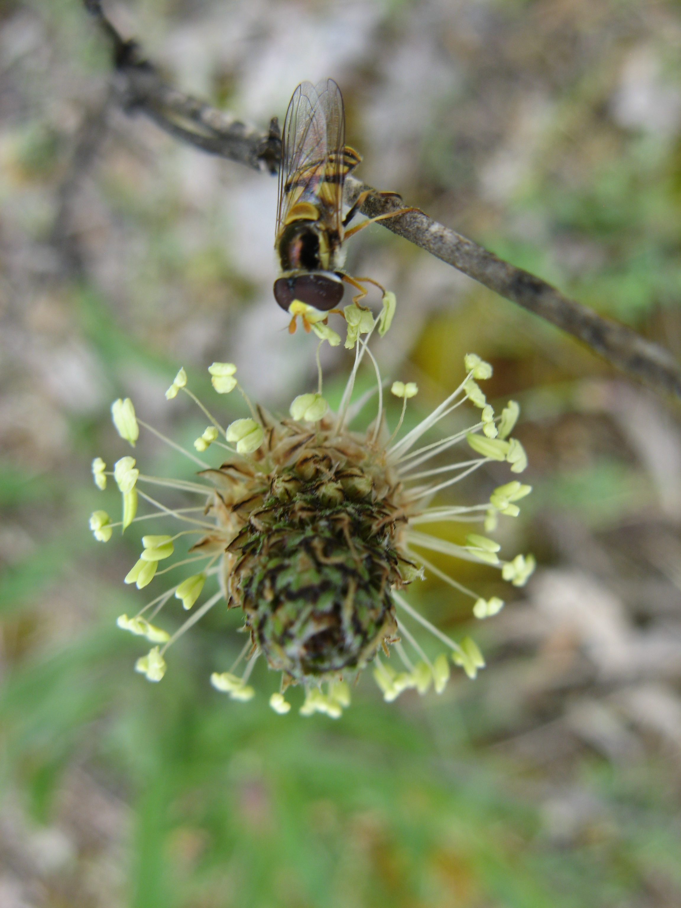
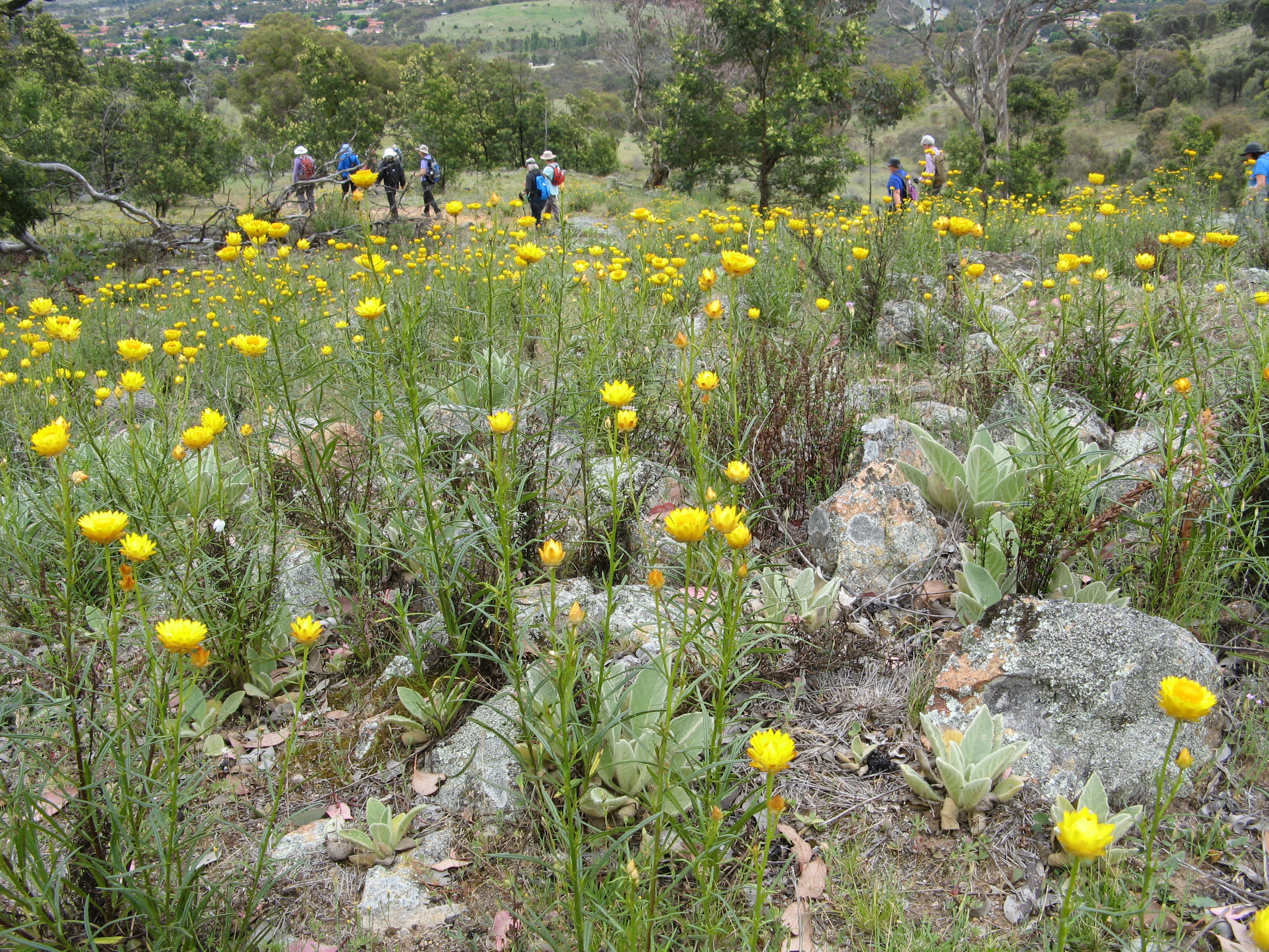 Tuggeranong Hill, almost our back yard, was abloom. Fields of spring flowers coloured our short trek with white, yellow, mauve, pink, purple, blue. Some were weeds but still beautiful and colourful. Some were clustered in isolated groups and others cascaded across the grasslands or lit up the woodland floor. Tiny daisies sprinkled themselves in clumps of lichened rocks. Vanilla lilies danced in the breeze. On the north western sunny side of the hill the wattles brought a pale yellow blush to the greens of the grasses and tree foliage. Yellow everlastings seemed to shine with their own brightness against the overcast, darker blue of the distant Brindabella Ranges. I enjoyed the job of “tail-end-Charlie”, keeping an eye on the slower members of the group, supporting the uphill strugglers and dashing round taking as many flower photos as I could during the walk. Ah. Pleasure indeed.


 Back down on the flat near the back of our house I photographed some of the walkers foregrounded by a large spray of small white everlastings. The gum tree above had been home to a pair of tawny frogmouths who had now gone.
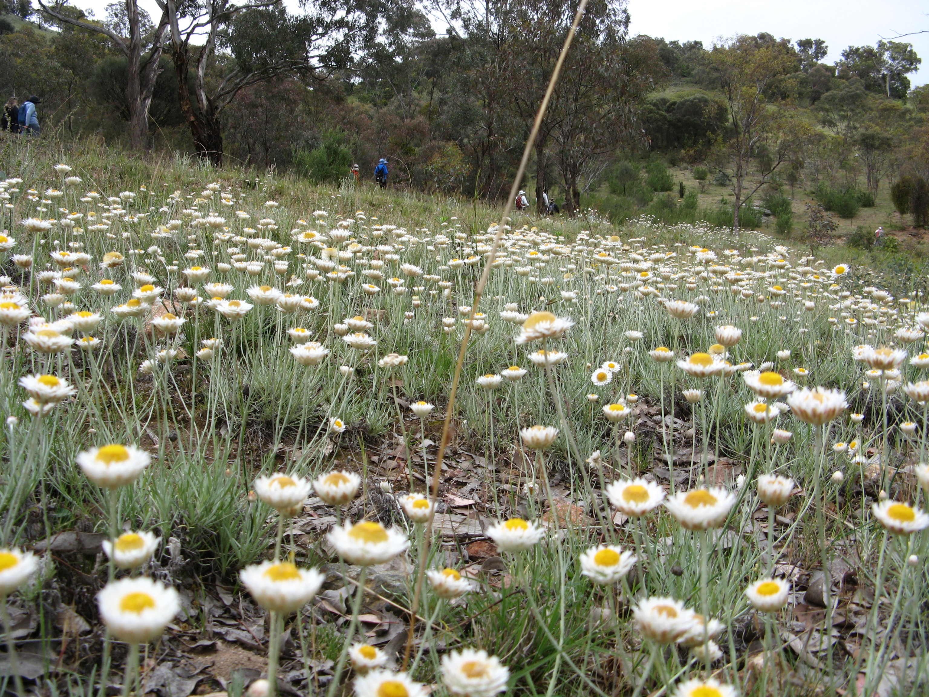


 How to narrow it down? That was the trouble. Balancing the desire for full adventure with funds and loved ones and time and the planet.


 By morning the wind had blown itself out. We had a last wander through the blue gums. William and I found a massive old ancient eucalypt. It stood tall like Dad as I remember him. Strong, dependable, gnarled, firmly rooted to the earth. Standing quiet among its kin. Was there a twinkle in the sun’s reflection on the leaves above?
 We’d come up the unmaintained horse track instead of the intended Rodriguez Pass Track and ended up high on the ridge below Evans Lookout. So we headed down the steps to pick up the Grand Canyon Track. It’s an old trail built in the Depression, hewn out of rock in some sections. Along the creek was sublime. Waterfalls tumbledover green walls past perched tree ferns to the black canyon floor. Cold. Moist. Water bubbling over smooth rocks. In his book Dad wrote about his first trip to the Blue Mountains. His father had taken him on a hike with borrowed pack, sleeping bag and swag. The trekked through Wentworth Falls, camped in a picnic shelter, Laura, Katoomba, Medlow Baths. They stayed a night in Wall’s Cave which left a great impression him. “Firelight and shadows on the roof of the cave many feet above”. From there they went through the Grand Canyon and down Beauchamp Falls which was our intended route up. They finished going up Govetts Leap and back to the train station. Quite a walk. On the track above the canyon I tell Bob and Sue, friends from work at the outdoor school years ago, about the abseil and canyon trip I have guided lots of times for students in the depths below.


